T&S Technology Development Co., Ltd has a long time of operation
with extensive experience in many fields, especially in the field
of Geophysical survey: Building foundation survey,
Hydroelectricity, Underground water exploration, and Mineral
exploration... In addition, there are many other fields such as
Geological Survey, Geodesy, and Hydrology.
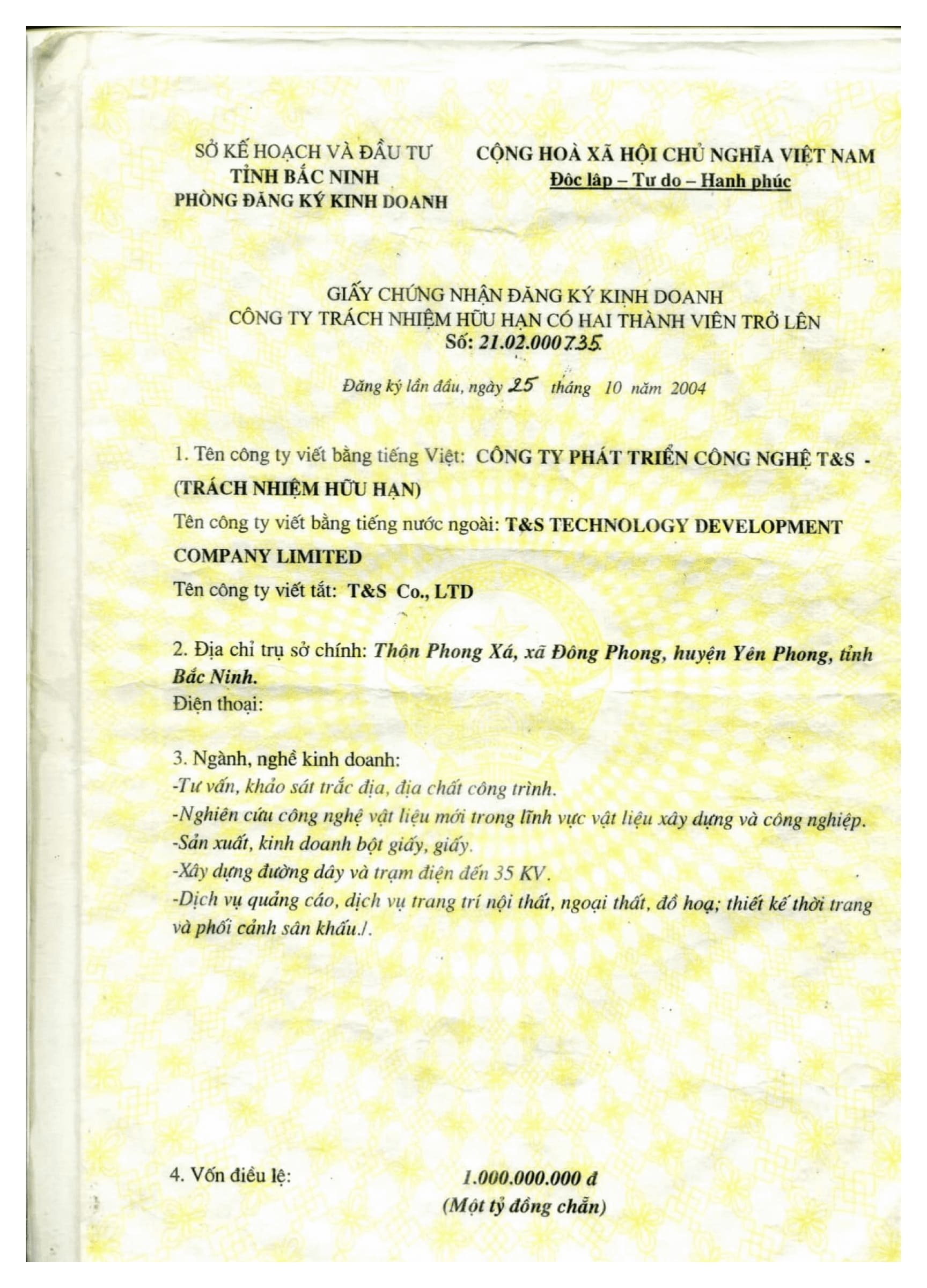
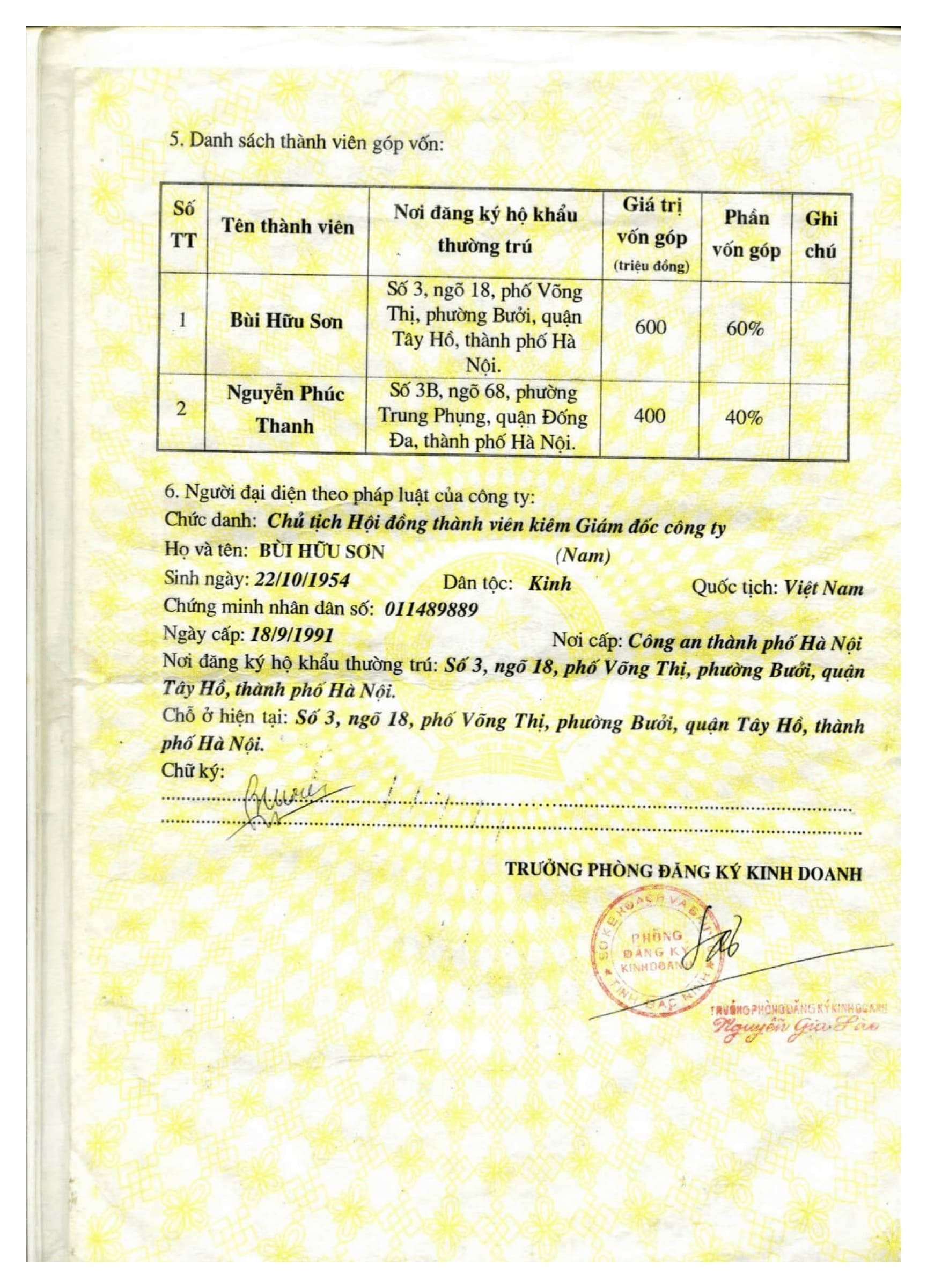
T&S Geophysics full name is T&S Technology Development Co.,
Ltd., the company was established under the Operation License
issued by the Department of Planning and Investment of Bac Ninh
province on October 25, 2004.
Enterprise code number 21.02.0735 issued by the Department of
Planning and Investment of Bac Ninh province on October 25, 2004.
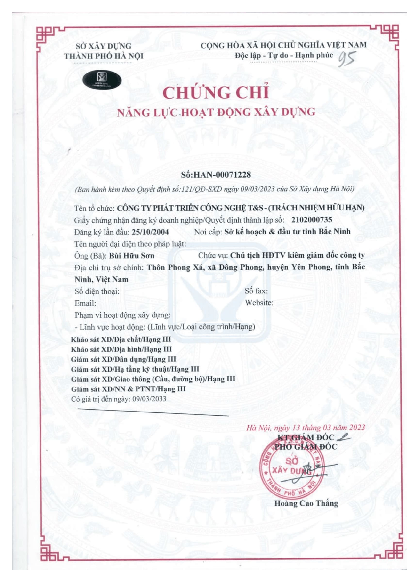
Certificate of competency in construction activities No.
SXD-00005594 Grade 3 in the field of Geological Survey,
Topography, Consulting and Supervision of works issued by Hanoi
Department of Construction on March 23, 2023.
T&S has a team of skilled engineers and workers who are formally
trained in universities and colleges, always supplemented with
capacity and professional knowledge through each project, with a
strong work ethic and high efficiency.
The company regularly maintains training to improve the
professional qualifications and skills of the staff.
With the strength of the ability to research and apply technology,
the company has equipped with highly specialized machinery and
equipment to meet the most stringent requirements.
The company has a cooperative relationship with many units, many
colleagues operating in the fields of research, education, and
training to continuously update and apply new technologies in
their fields of activity.
With equipment, experience, professional qualifications and
self-improvement spirit of the staff, T&S provides customers with
the fastest, most accurate and perfect survey services.
Areas of activity and services provided
At T&S Technology Development Co., Ltd we provide and consult
services in geophysics and other fields.
T&S Technology Development Co., Ltd has a long time of operation
with extensive experience in many fields, especially in the
field of Geophysical survey: Building foundation survey,
Hydroelectricity, Underground water exploration, Mineral
exploration... In addition, there are many other fields such as:
Geological Survey, Geodesy, Hydrology.
Seismic survey of Ching fong cement factory (Thuy Nguyen
district) - Hai Phong)
Geophysical survey of Thai An Hydroelectricity (Quan Ba district
- Ha Giang)
Xekaman Hydroelectricity Seismic Survey - 3 Se Kon Provinces -
DPR Laos)
Geophysical Survey of Huoi Lam Phan - Thuong Hydropower Plant
(Muong Tha) Teeng, Se Kon Province - Lao PDR)
Geophysical survey for iron ore exploration (Phu Nhuon, Xieng
province) Around - Laos)
Geophysical Survey: Dak My - 2 Hydroelectricity (Phuoc Son
district - Quang Nam)
Geophysical Survey of Nam Xay Noi Hydropower Plant - 2 (Van Ban
district - Lao Cai)
2D Electrical Depth Survey: Groundwater Exploration in Islands:
Thanh Lan, Co To, Quan Lan, Ngoc Vung belong to COTO district,
Ha Long Bay, Quang Ninh
Geophysical Survey Underground water exploration in Pha Long
region (district) Muong Khuong - Lao Cai)
Geophysical Survey of Sap Viet Hydroelectricity (Yen Chau
district - Son La)
Geophysical Survey of Salt - Gypsum Mine, Xavanakhet Province -
Laos)
Geophysical Survey of Dak My 2 Hydropower Plant (Phuoc Son
District - Quang Ninh Province) Male)
Geophysical Survey: Dak Rinh Hydropower Plant (Son Tay District
- Quang Ninh Province) Ngai)
Geophysical Survey of Huoy Lam Phan Ha Hydropower Plant (Laos
PDR)
Geophysical Survey of Xe Nam Noi Hydropower Plant (Lao PDR)
Geophysical Survey FORMOSA Vung Ang Steel Plant (District) Ky
Anh - Ha Tinh)
Geophysical Survey of Nam Kong Hydroelectricity (Laos PDR)
Georada method survey of 21 weak tunnels of Hanoi railway line -
Ho Chi Minh City
Geophysical Survey: Karsto Cave, Ngan Son Railway Bridge, Khe
Tinh (Bo Trach and Tuyen Hoa, Quang Binh)
Seismic survey of borehole and resistivity measurement of
Thermal plant Duyen Hai 3 Palace - Tra Vinh
Seismic survey of borehole and resistivity measurement of
Thermal plant Vinh Tan 1 and 4 power station ( Huyen Tuy Phong,
Binh Thuan province)
Seismic survey of borehole and resistivity measurement of
Thermal plant Thai Binh 1, 2 electricity, Thai Binh province
Measurement of Carota borehole in Kaleum coal mine, SE KON
province, LAO
Survey of parallel seismic method to determine pile depth,
concrete foundations of buildings on the Metro Line from Kim Ma
- Hanoi station phase 1 and phase 2
Survey of refractive seismic, transverse seismic of boreholes,
thermal measurement - resistivity of Nghi Son 2 thermal power
plant, Thanh Hoa
Refraction seismic survey Phuoc Tuong Tunnel - Phu Gia (Town)
Lang Co - Thua Thien - Hue province)
Refraction seismic survey of Mui Chau Tunnel (Range of La Son -
Tuy Loan, Da Nang)
Refraction seismic survey of Cu Mong Tunnel (Tunnel construction
investment project) road through Ca Pass (Binh Dinh - Phu Yen
section)
2D resistive imaging depth survey: The landslide section of the
Lower Expressway Long - Van Don: Point Km 26 and Km 27+800
Refraction seismic survey of Tam Diep Tunnel and Thung Thi
Tunnel in North-South Expressway
Refraction seismic survey: Tam Diep Tunnel and Thung Thi Tunnel
belong to North-South Expressway in Ninh Binh and Thanh Hoa
provinces)
Multichannel surface wave (MASW) refractive seismic survey,
power plant Wind Hoa Thang: in Hoa Thang, Bac Binh district,
Binh Thuan province
Seismic and deep 2D electrical survey of Babonueu Tunnel, Vung
Ro Tunnel 1 , Vung Ro 2 Tunnel, Vung Ro 4 Tunnel, Bai Gio Tunnel
(Renovation Project of Tunnel on the Vinh - Nha Trang railway
section)
Exploration of 2D photoelectric depth measurement method, wind
power plant project Huong Tan, Huong Hoa district, Quang Tri
province
Exploration of 2D photoelectric depth measurement method, wind
power plant project Tan Linh, Huong Hoa district, Quang Tri
province
Doc San Tunnel Refraction Seismic Survey: In Cam Ranh - in Cao
North - South expressway, (Nha Trang - Cam Lam section,
belonging to the Expressway project) North South)
Refraction seismic survey of Tuy An Tunnel (Km 04+970), Tuy An
district, Phu Yen province (Construction Component Project of
Quy Nhon - Chi Thanh section, North-South Expressway project)
Refraction seismic survey Tunnel 1, Tunnel 2, Duc Pho district,
province Quang Ngai (Construction Component Project of Quy Nhon
- Chi Thanh section, North-South Expressway project).
Refraction seismic survey of Son Trieu Tunnel: (Construction
Component Project) Quy Nhon - Chi Thanh section, part of the
North - South Expressway project). (Attend component project of
Quang Ngai - Hoai Nhon section, Binh Dinh province, belonging to
North - South Expressway project)
Refraction seismic survey of Dong Nang Tunnel (KM 578+140), Ky .
district Anh, Ha Tinh Province (Construction Investment
Component Project of Vung Ang - Bung, part of the North - South
Expressway project)
Refraction seismic survey Tunnel 1 - Tunnel 2 - Tunnel 3 (KM
14-KM51), Da Bac district and Mai Chau district, Hoa Binh
province
Survey of depth measurement of 2D electrical images, Nam Chan
hydropower project, Sin . district Ho, Lai Chau Province
Surveying depth measurement of 2D electric images, Nam Cuoi 1, 1
B hydropower projects, Nam Nhun district, Lai Chau province
Survey of depth measurement of 2D electric images, Chieng So 2
Hydropower Plant, Dien district Bien Dong, Dien Bien province
Surveying and measuring depth of 2D electrical images, Hua Bun
hydropower project, Nam . commune Ban, Nam Nhun district, Lai
Chau province
Survey of depth measurement of 2D electric images, Song Con 3
hydropower project, district Bac Quang, Ha Giang province
Survey of depth measurement of 2D electrical images, Nung Than 1
hydropower project, district Phong Tho, Lai Chau province
Horizontal seismic survey between boreholes at Power - Gas plant
(Nhon Trach district, Dong Nai province)
Survey of 2D resistive tomography to locate Karsto . cave on the
Hanoi - Ha Giang highway
Business capacity
Since the establishment of the Company, with an open and open
mechanism, it has attracted many qualified and skilled
scientists and technicians in many fields, especially in the
field of Geophysics - Geology - Geodesy. .
The company has equipped with modern equipment and applied
geophysical exploration methods, with advanced processing
software to solve complex geological tasks.
Currently, the total number of employees of the whole company
is 26 employees, of which:
Engineer: 5
College: 5
Intermediate: 6
Workers: 10
Equipment and technology
T&S Company (Limited) has equipped with synchronous and modern
technological equipment to perform all types of work in the
field of geotechnical survey and survey, including:
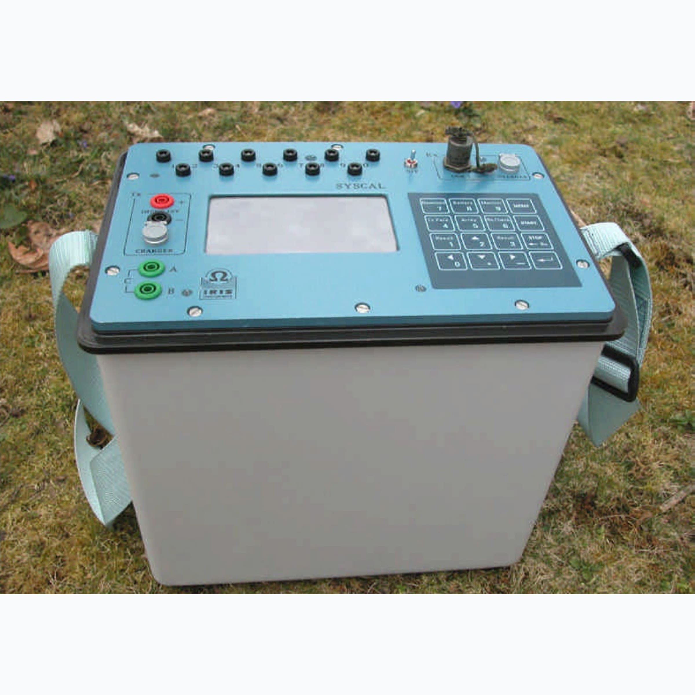
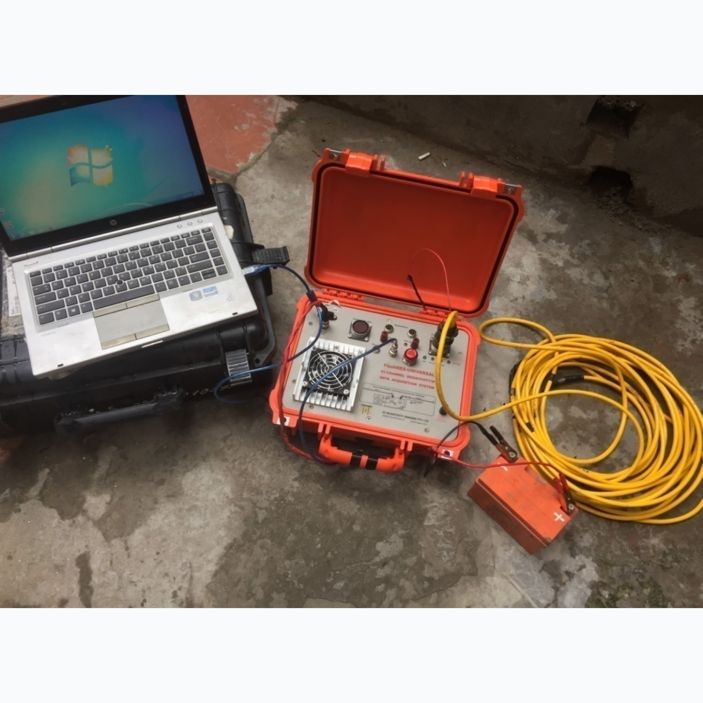
2D resistivity imaging depth device (2D tomography)
Figure 1. Syscall Pro Switch-48 . Photoelectric depth
measuring device: Syscall Pro Switch-48
Application in geological survey, engineering geology,
exploration Mineral and groundwater exploration, research depth
to 120 meters.
Using 2D, 3D resistivity tomography depth measurement by
device Multipolar measurement: 48 electrodes (Electrisal
Resistivity Tomography: ERT), with 10 different electrode
array arrangements, emitter voltage as high as 1000 volts,
emitter current: 2.5 Amps: Symmetrical depth measurement
Slumbeger; Wenner symmetric depth measurement; Symmetrical
depth measurement Slumbeger-Wenner; Dipol-Dipol depth
measurement; Measure Pol-Dipol; Pol-Pol; Measure resistivity
on shallow water rivers and seas, Measure potentials course;
Measure electrical cross-section.
2D, 3D measurement with high density of data points, automatic
data storage Dynamic, high accuracy, Data collection capacity
is many times times that of conventional depth gauges.
Measure polarization with 20 attenuation windows, to determine
the parameters No.: Resistivity (Om.m)
Measuring polarization value 20 windows: from M 1 to M 20,
attenuation time total decrease T, attenuation time half T1/2,
decay rate , to determine the boundaries and thickness of the
conductive ore bed, diffuse ore (Metal coefficient: metal
content), aquifer water, coal seam.
Data is downloaded via USB 232C port, then run directly on
RES2DINV software, the Geology - Resistance . section pressure
immediately after measuring in the field.
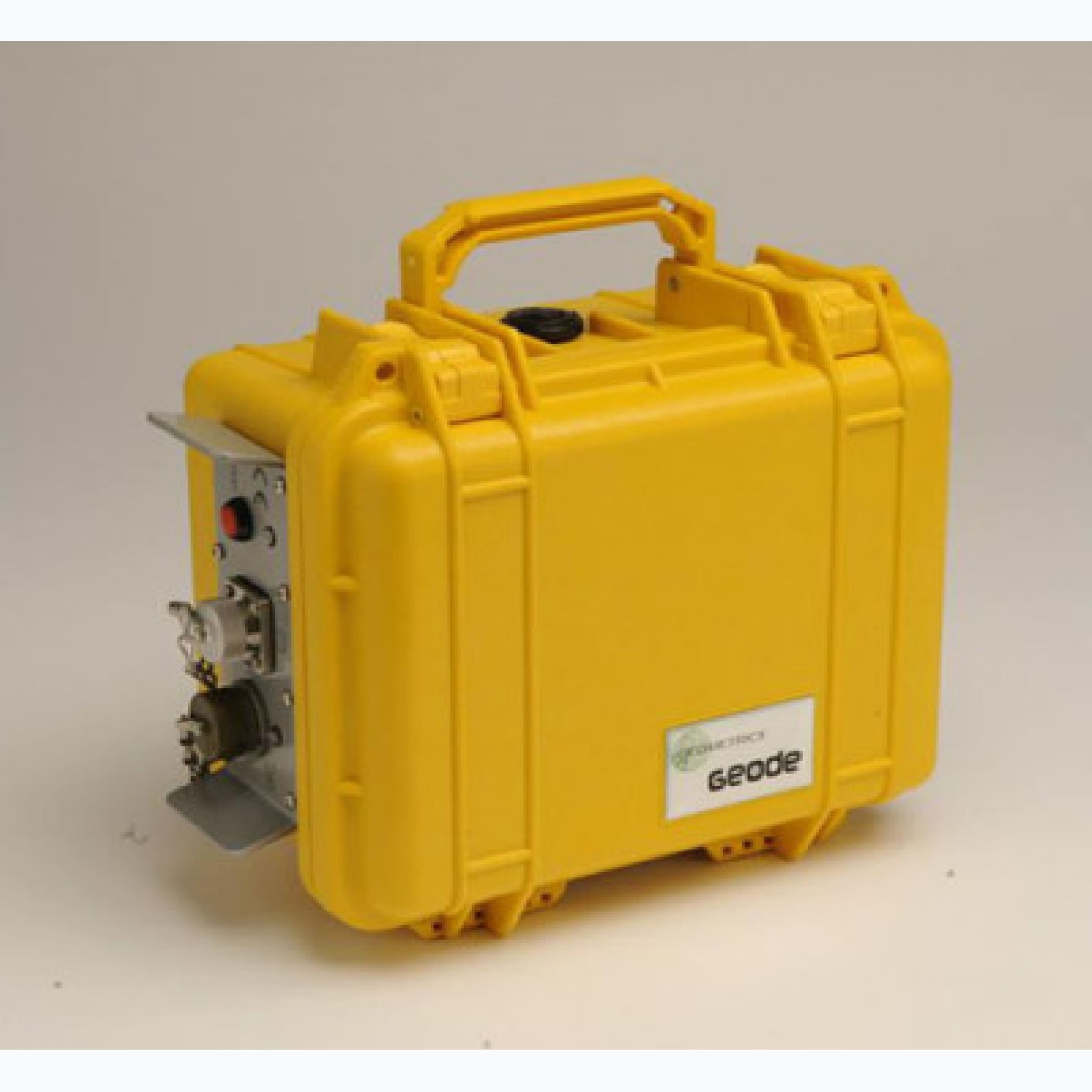
Seismometer: GEODE ES-24 (24 US Channels)
Figure 3. Geode ES24 seismometer (Geometrics - THE USA)
Seismometer ES-24 (24 US channels)
Figure 4. ES-24 seismic recorder (24 US channels)
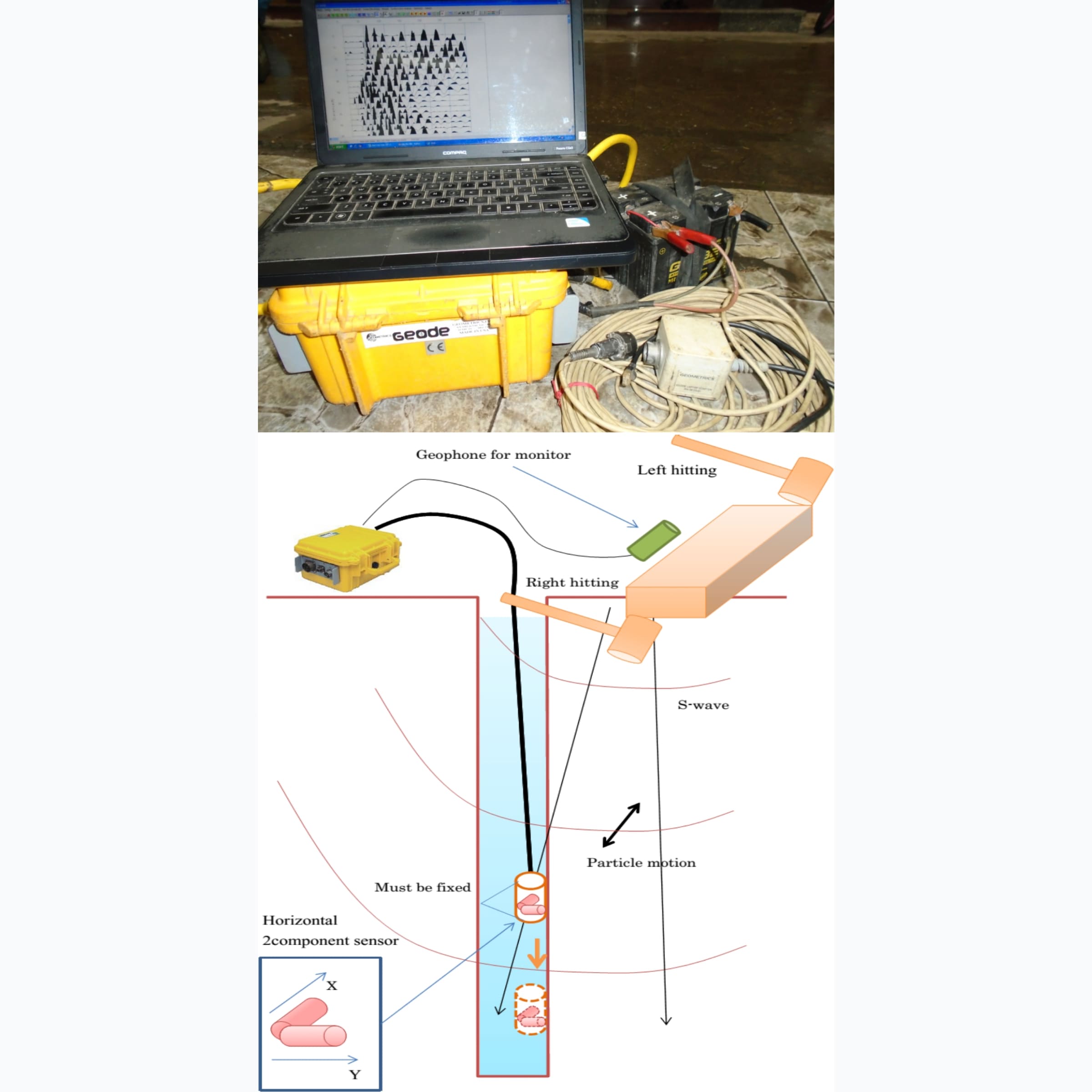
Used for refractive seismic, reflected seismic, geo earthquake in
borehole
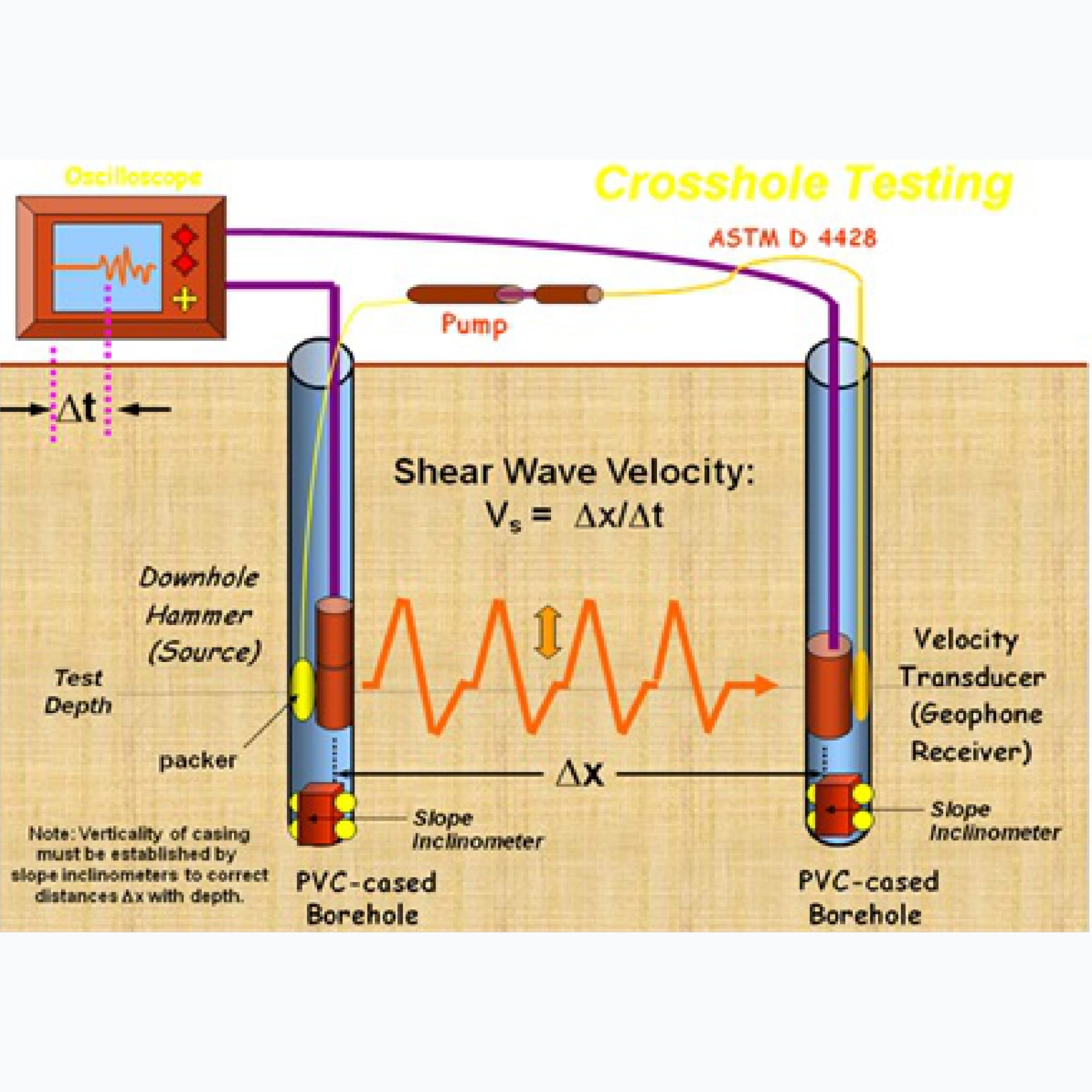
Seismic measurement in borehole
Principle diagram of seismic survey in borehole
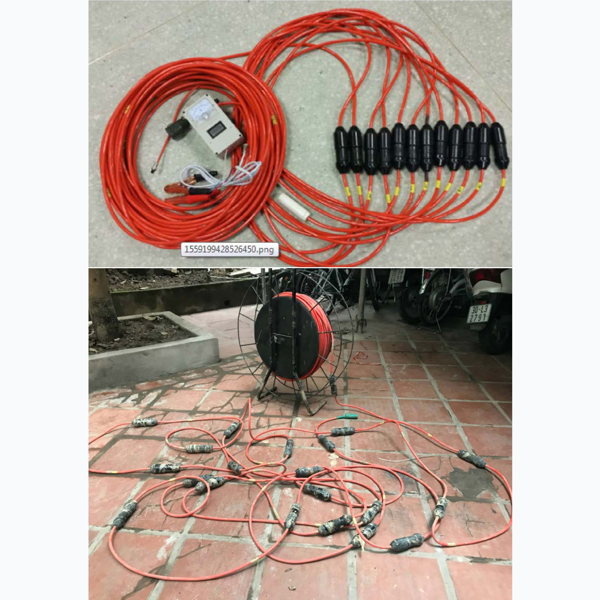
Receiver under borehole
Includes 2 receiver blocks, distance between 2 receiver
blocks: 1 meter, each block including 01 Vp vertical wave
receiver and 02 Vs . horizontal wave receiver
2D resistivity imaging depth device (2D tomography)
Figure 5. Seismic receiver under the Borehole
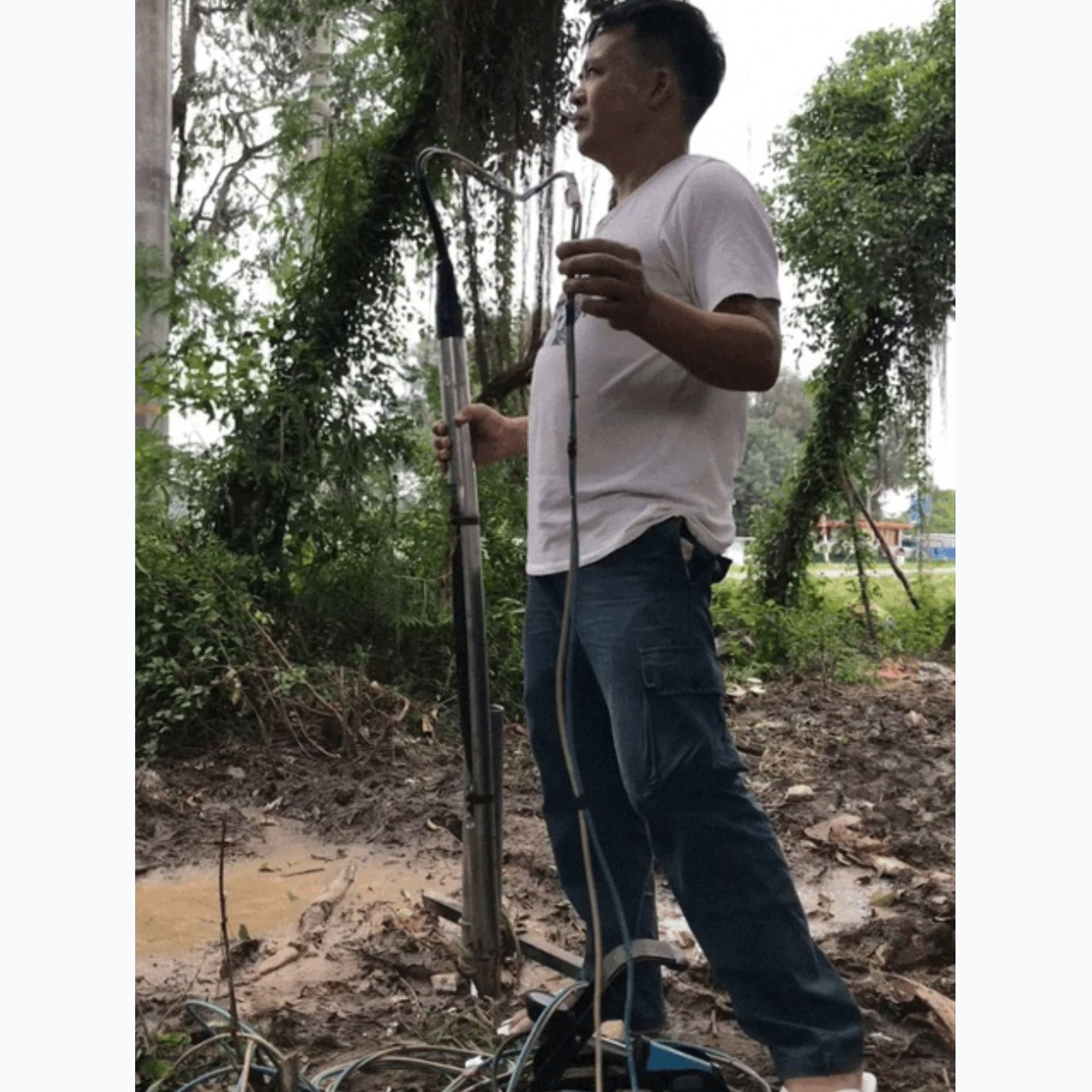
Seismic transmitters in the borehole
Figure 6. Diagram of Crosshole . seismic measurement
principle
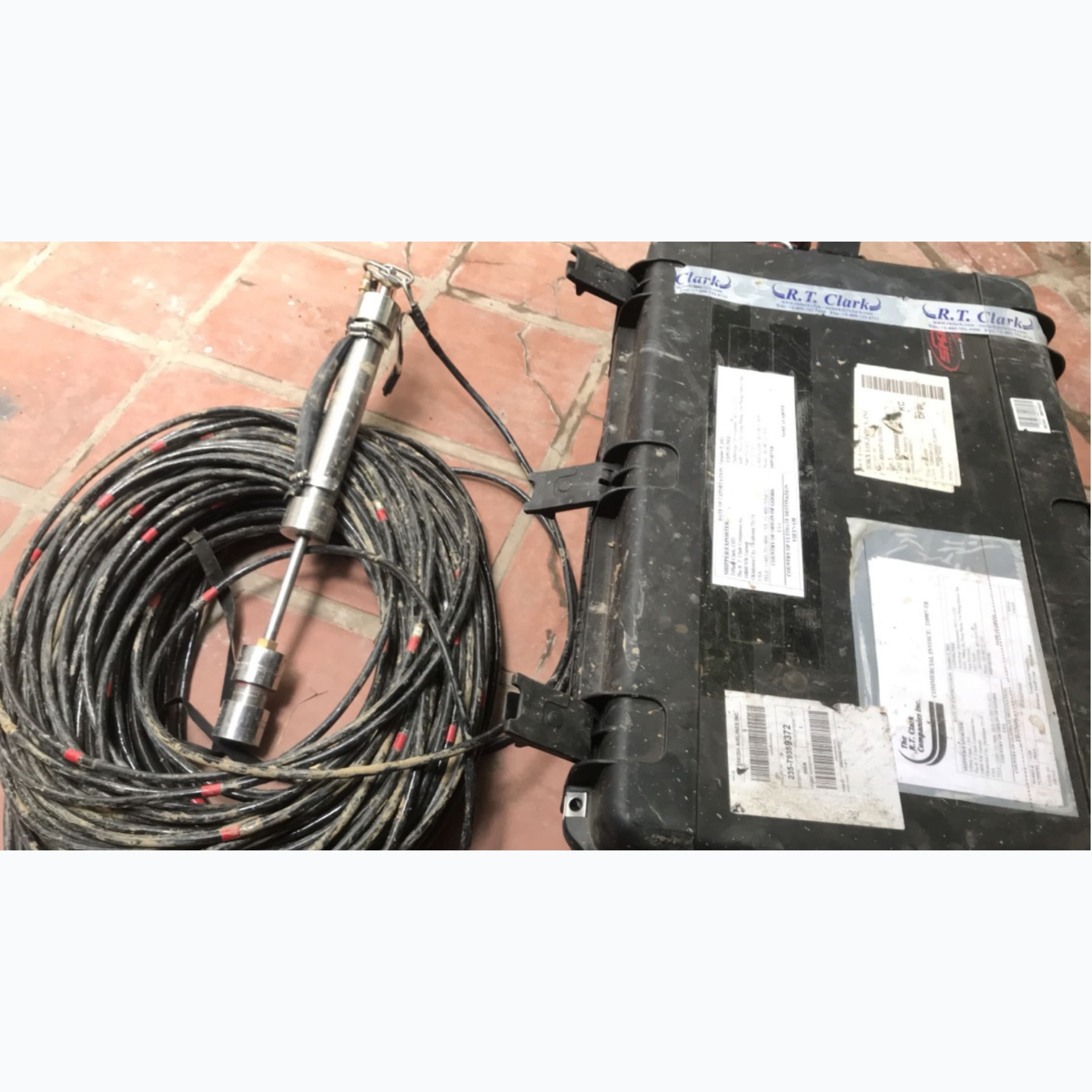
Figure 7. Transverse rich wave source in borehole BALLARD
Borehole Shearwave Source (BALLARD, USA)
Plasma explosion by high voltage wind, creating waves in the
pit drill to measure transverse seismic between boreholes
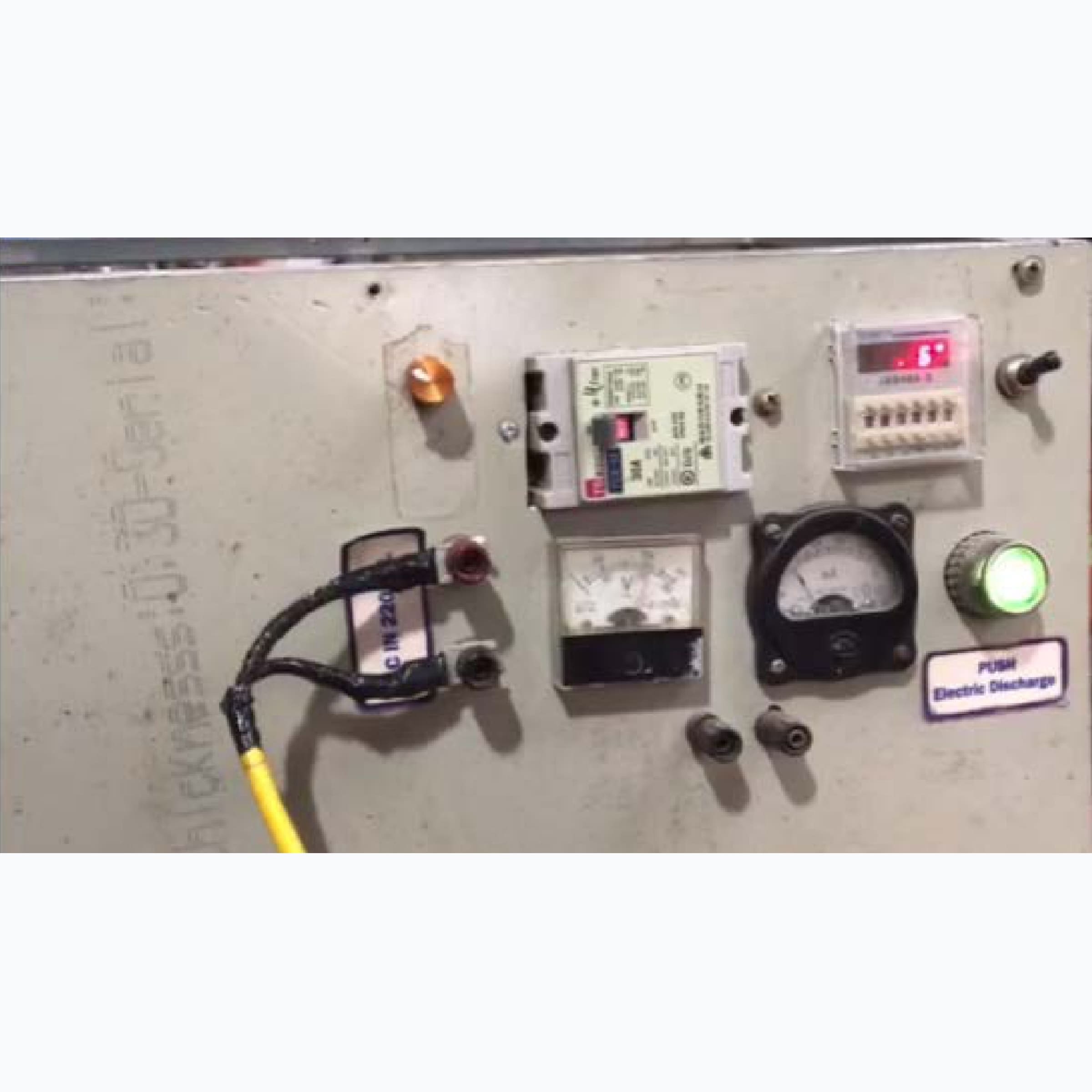
Figure 8. Plasma seismic wave generator in borehole
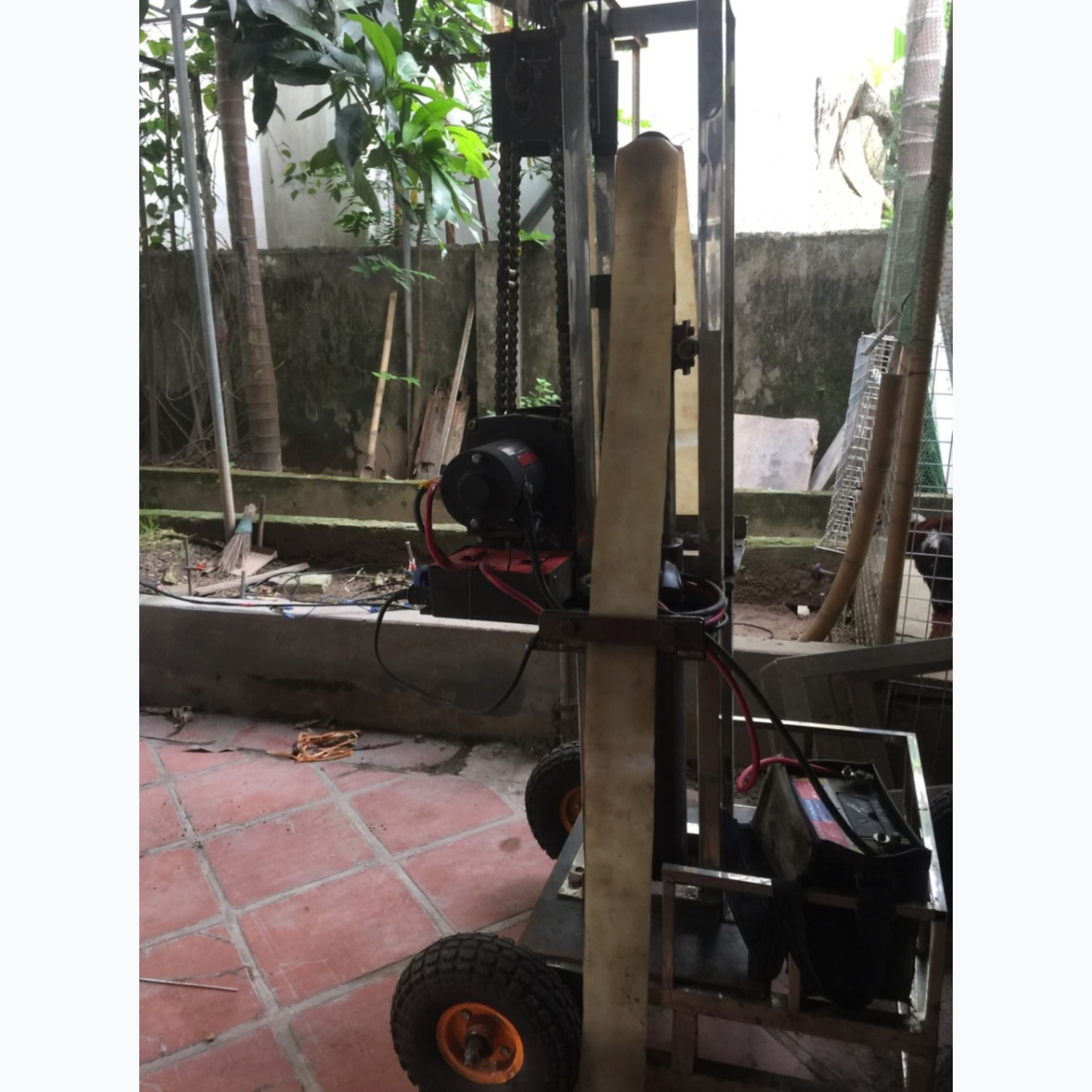
Automatic machine hammer device - remote control, power from
ac qui: Generate waves for seismic measurements in areas that
are not allowed blasting spells
Figure 9. Automatic remote control hammer
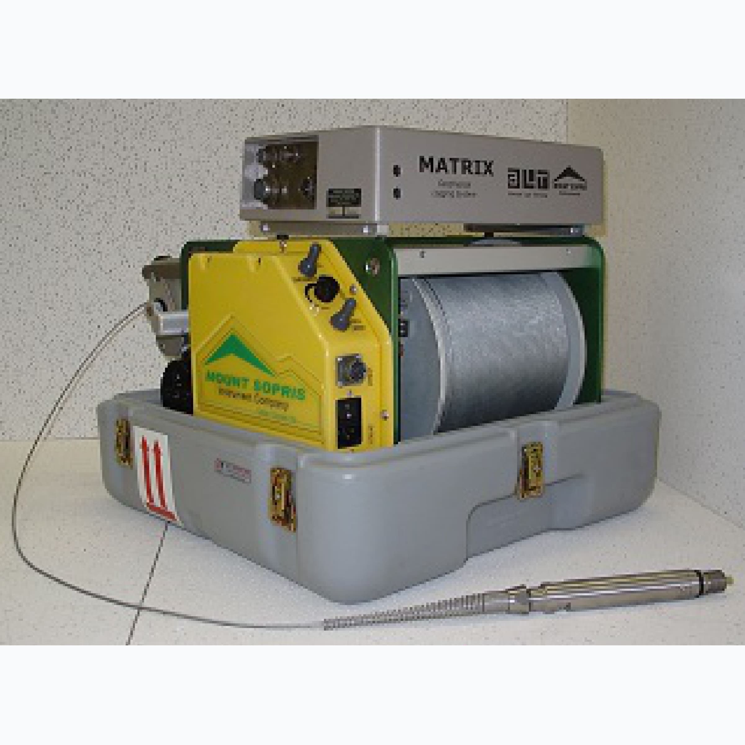
Carota Matrix Logger measuring station manufactured by Matrix
(USA)
Specialized in measuring Carota Geophysical methods in
boreholes with depth up to 500 meters, used for geological
survey, geology construction, coal exploration: Measuring soil
density (Gama-Gama scattering), natural gamma parameter of
rock (Gamma), measure longitudinal resistivity borehole wall,
measure natural potential, measure borehole diameter, measure
degree borehole deviation.
Figure 10. Carota measuring station in borehole
24 channel receiver: Measuring longitudinal seismic waves in
borehole
Figure 11. 24-channel receiver: Measuring longitudinal
seismic waves in the crater wait
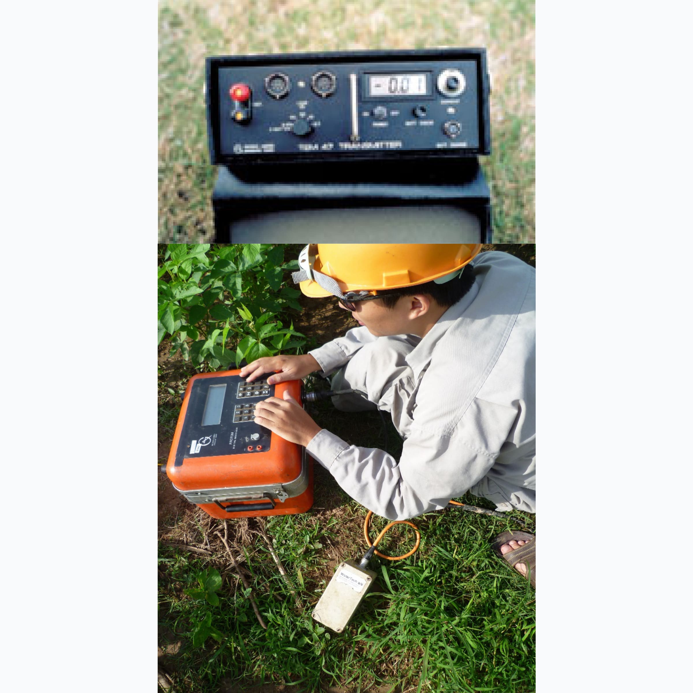
Electromagnetic field measuring device: TDEM 47 HP (GEONICS
company of Canada)
Figure 12. PROTEM Time Domain Electromagnetic Measurement
System (TDEM): TEM 47HP: essential to suit many
applications, from research engineering and near-surface
environmental studies, up to three- raw materials at depths
of 500 m or more.
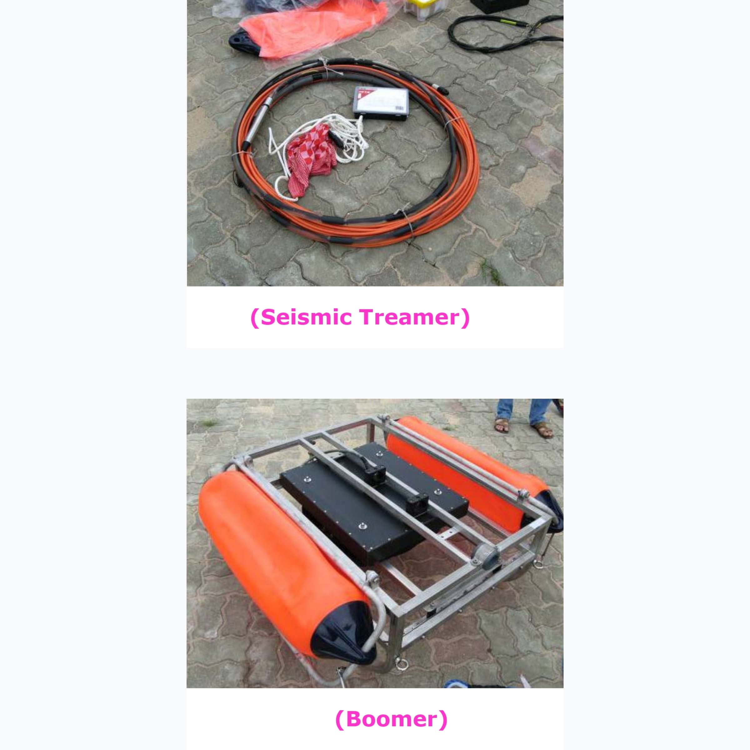
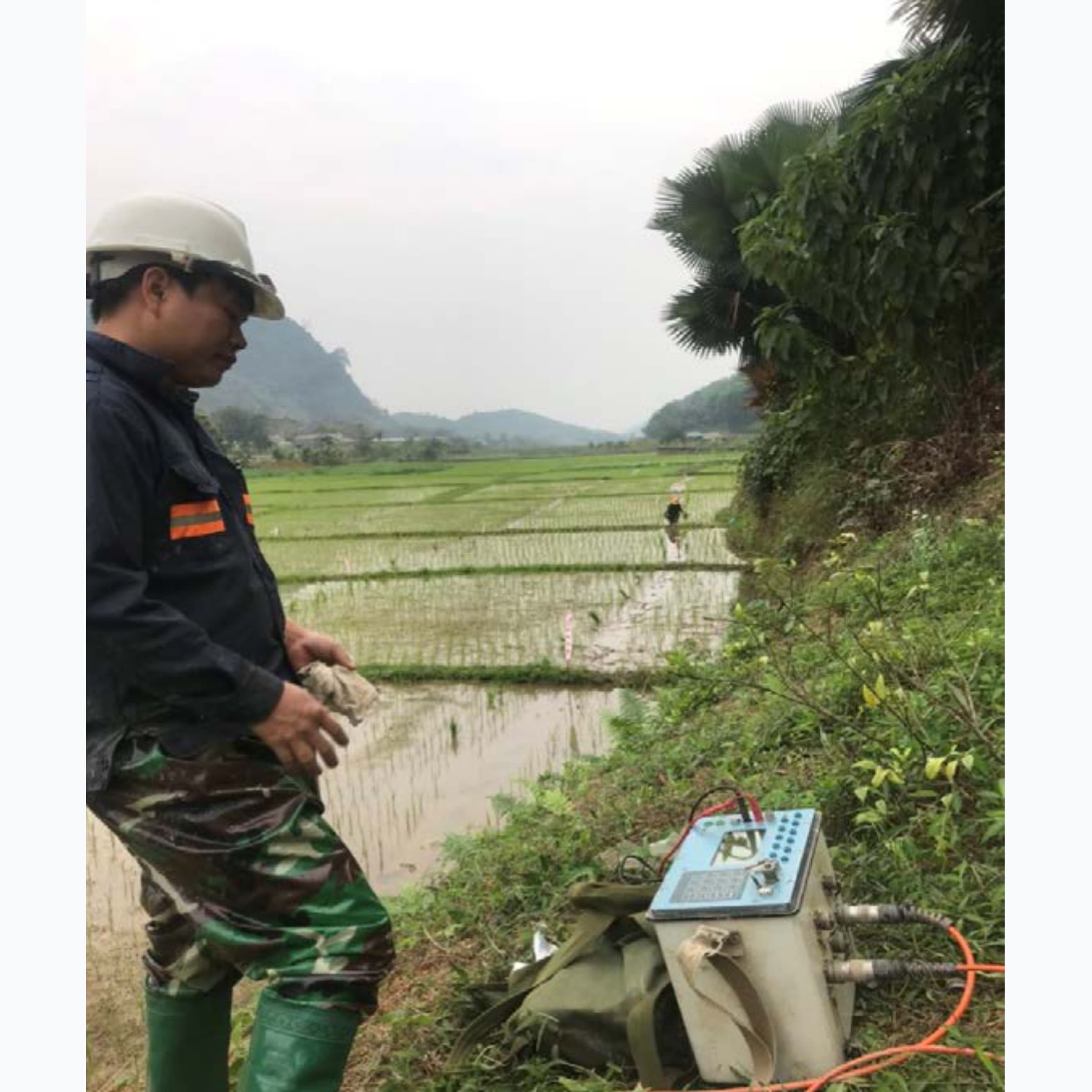
Short Sea Reflective Seismic Device
1.1 Ha's 5000 volt high voltage pulse generator, 1000 joule
capacity Lan (Geo Spark 1000 J)
Figure 14. 5000 volt high voltage generator
The controller collects seismic data
Figure 15. Controller and data collection
11.3. Receiver (24 Hydrophon series) and radio transmitter
shock (Bombo)
Figure 16. Signal receiver and seismic transmitter
Topographic measuring equipment
Global Positioning Meter RTK S800A (Italya): 3 pcs
Total station TM30- Leica - Switzerland/Total station TM30-
Leica- Switzerland): 02 sets (measurement accuracy: 0.5"
angle, measure side 0.6mm+1mm/km)
Total station TCA2003 - Leica- Switzerland / Total station
TCA2003- Leica- Switzerland : 02 sets (measurement accuracy
0.5” angle, measuring side 1mm+1mm/km): 2 pcs
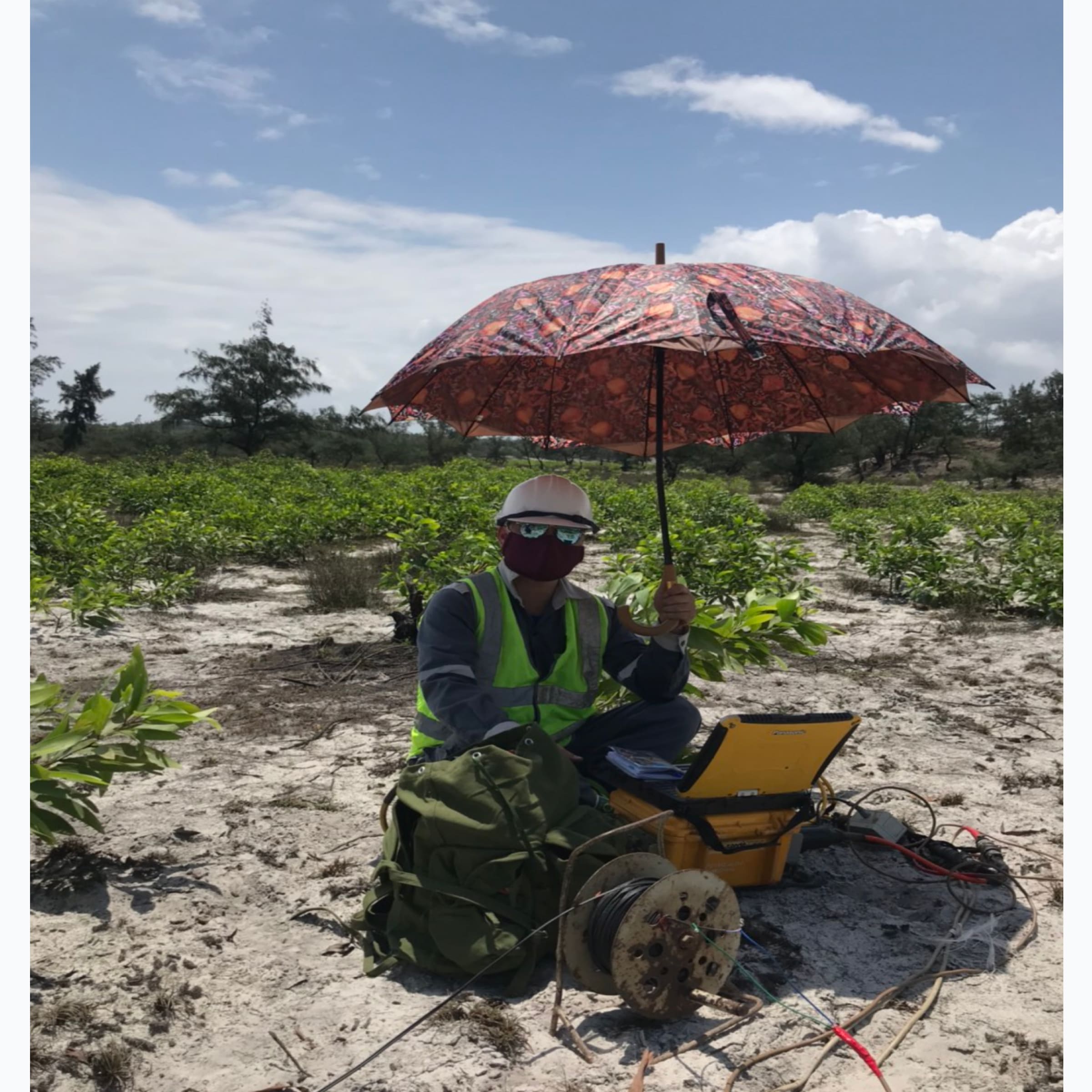
Some pictures of the company's equipment and activities
Below is a collection of images of the company's activities
during the implementation of the project that has been
implemented with the application of the technologies mentioned
by the company in the above Equipment and technology section.
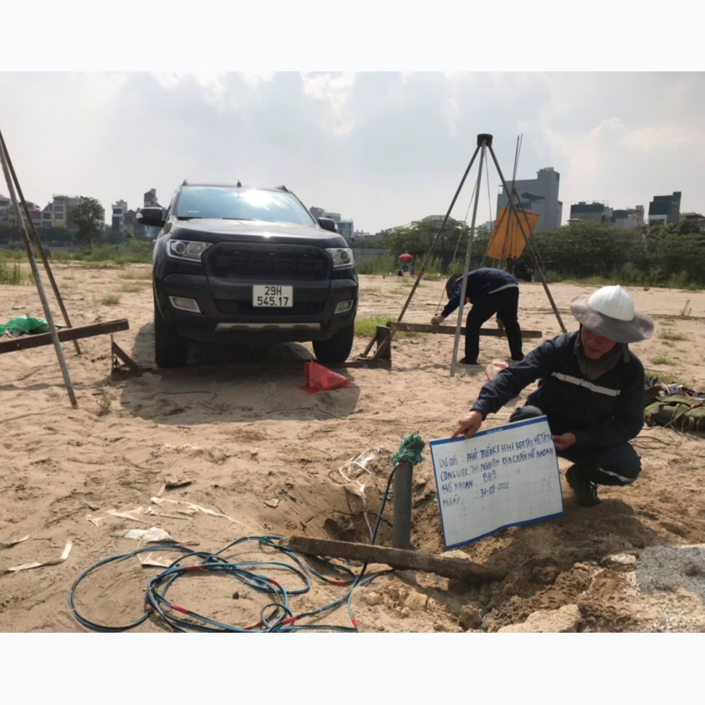
Figure 18. Seismic survey Drilling hole at the site
Figure 19. Survey of resistive tomography to locate Karsto
cave on Hanoi - Ha Giang highway
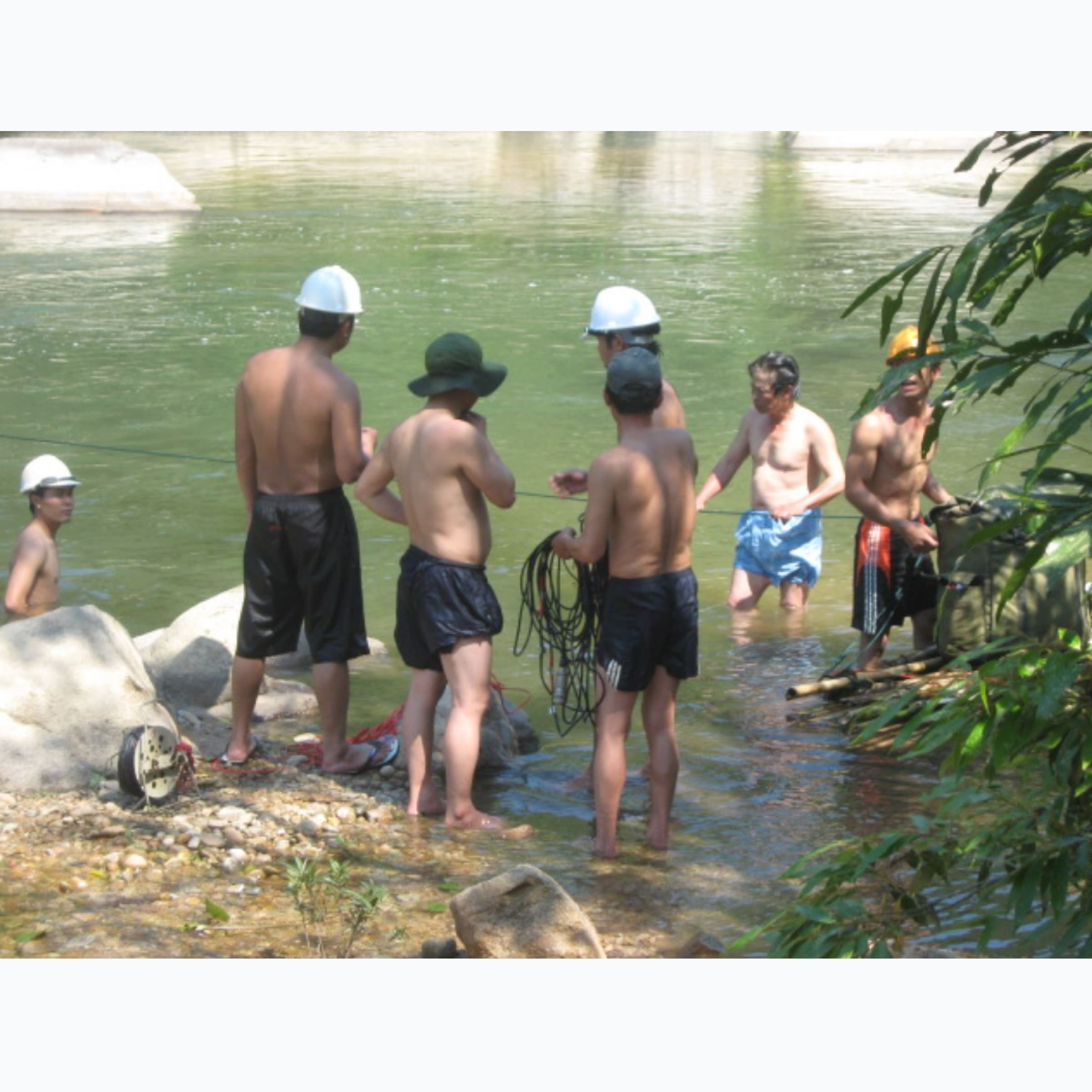
Figure 20. Horizontal seismic survey between drill holes at
Nhon Trach 3-4 Gas Power Plant (Nhon Trach district, Dong
Nai province)
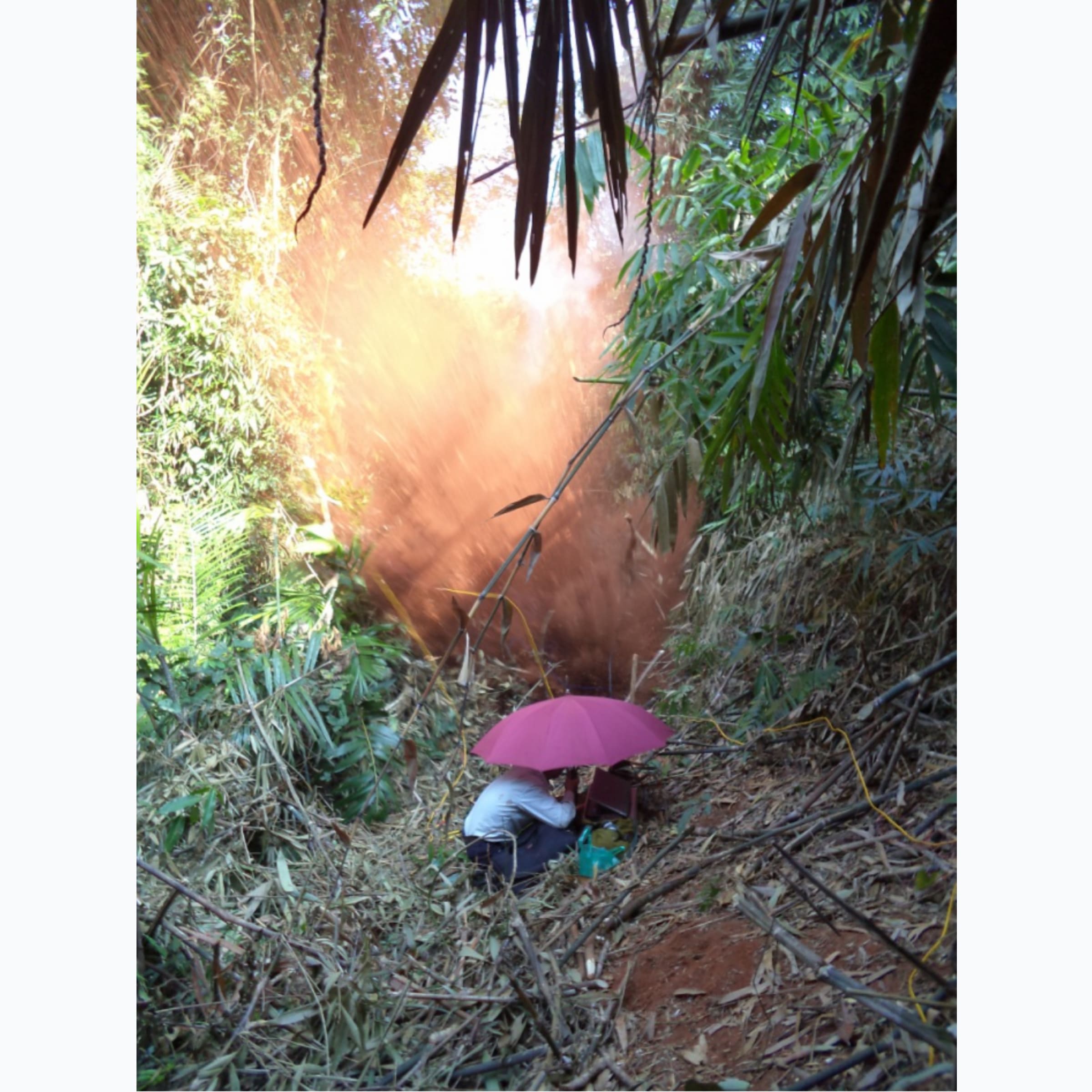
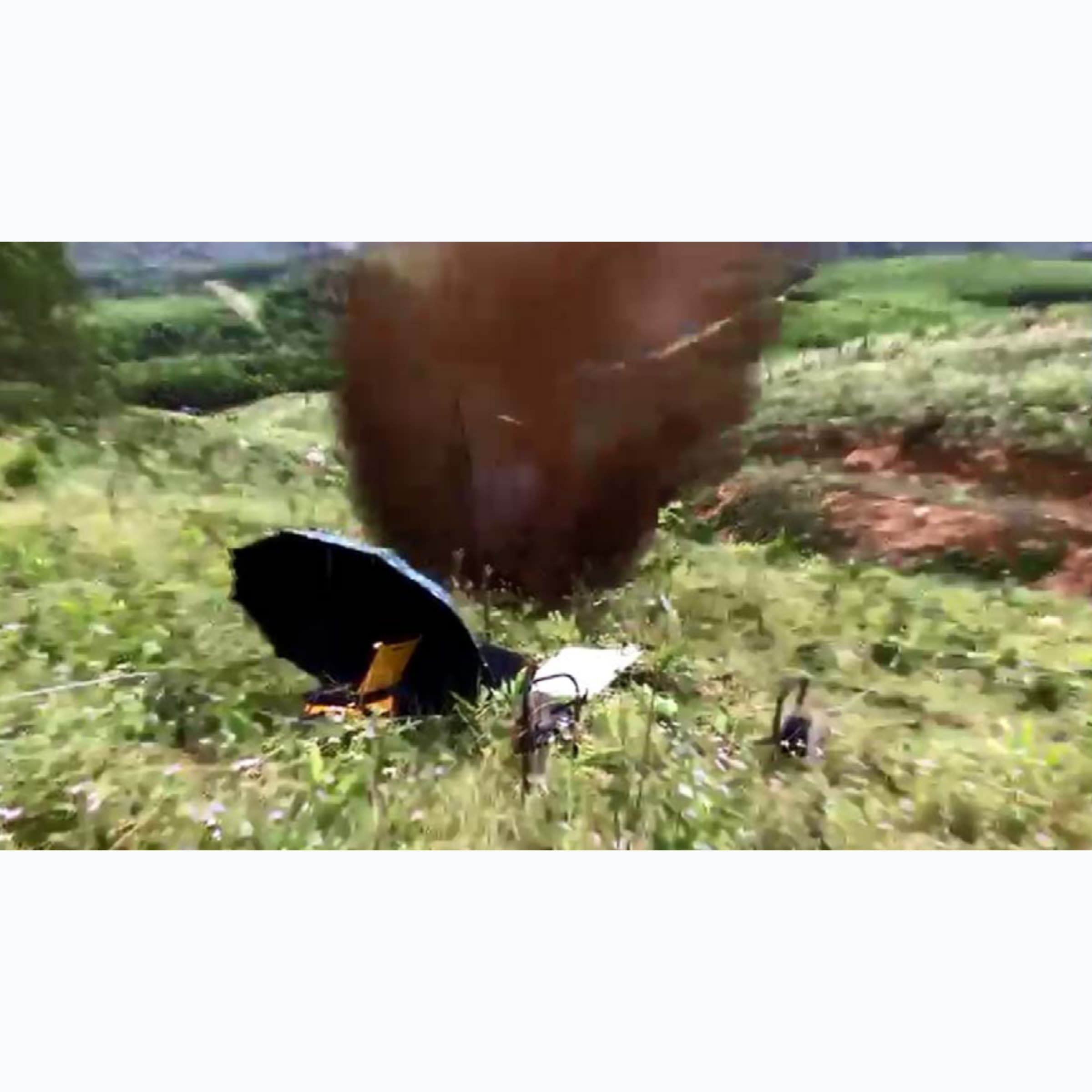
Figure 22. Mine blasting for seismic survey of Nam Kon
hydropower project (Laos)
Figure 23. Seismic survey of Dawk Rinh hydropower project
(Son Tay district, Quang Ngai province)
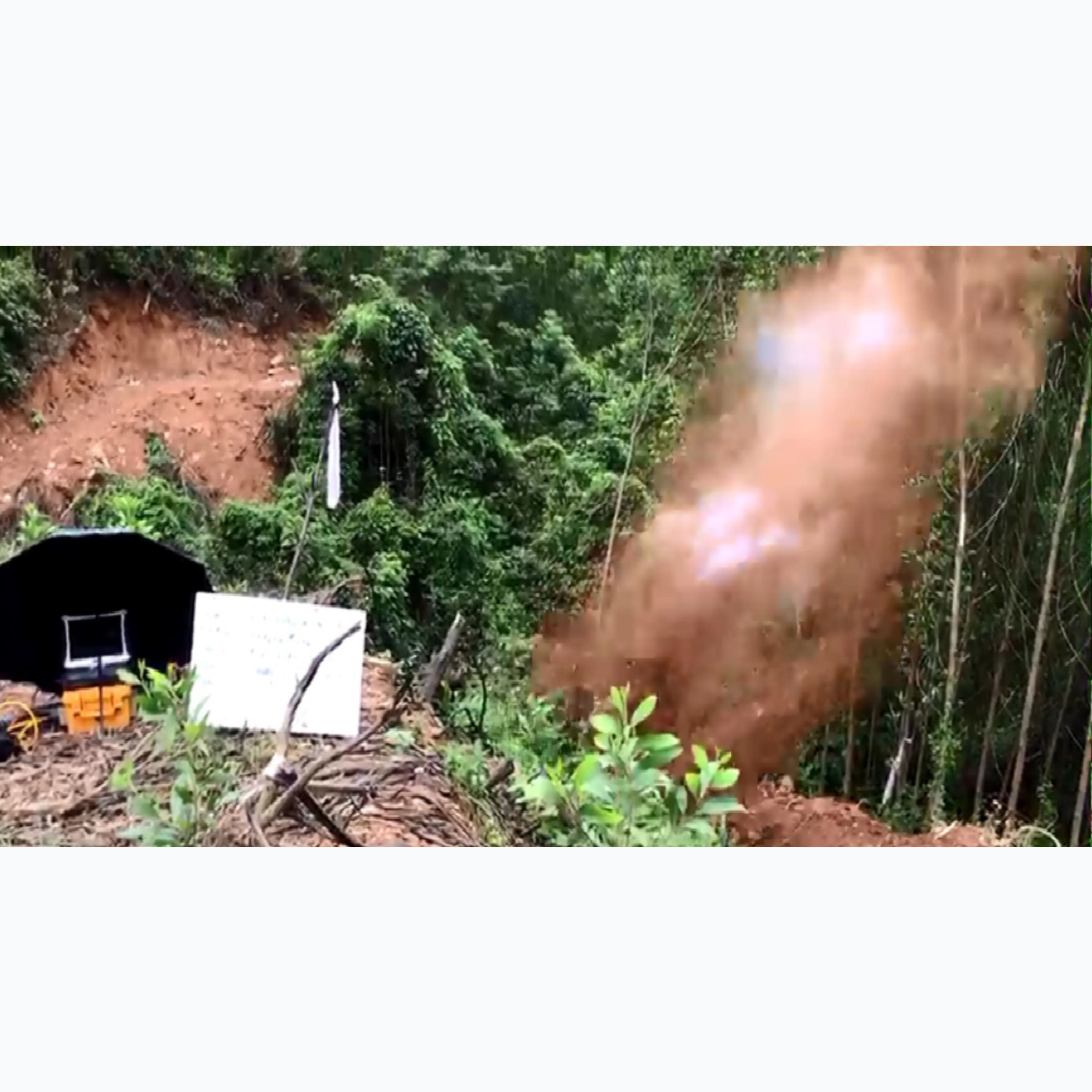
Figure 24. Mine blasting and seismic survey of Tuy An tunnel
project of North - South Highway (Tuy An district, Phu Yen
province)
Figure 25. Blasting and Seismic Survey of Dong Nang Tunnel
of North-South Expressway (Ky Anh District, Ha Tinh
Province)
Figure 26. Seismic survey: Multi-channel surface wave
spectroscopy (MASW), wind power project in Hoa Thang
commune, Bac Binh district, Binh Thuan province and Le Thuy
district, Quang Binh province
Level 3 Certificate in Geological and Topographic Surveying
activities
Issuing agency: Hanoi Department of Construction, No.
121/QD-SXD, March 9, 2023
Certificate of business registration
Issuing agency: Department of Planning and Investment - Bac
Ninh City People's Committee, October 25, 2004